Tracks: A Digital Window into the Journeys of Small-Scale Fishers
Small-scale fishers are the backbone of many coastal economies across the Western Indian Ocean. Yet despite their enormous contributions to food security and livelihoods, much of what they do happens out of sight—far from the data systems that guide policy and management.
To bridge this visibility gap, a new digital tool called Tracks, developed by WorldFish through the Asia–Africa BlueTech Superhighway (AABS) project, is changing that. By combining vessel tracking and self-reported catch data, Tracks brings new visibility to the daily movements, productivity, and safety of small-scale fishers.
WorldFish scientists see the tool as more than just a data platform "Tracks gives us a way to make fisheries data visible, useful, and is empowering those who create and own it," said Dr. Alexander Tilley, Senior Scientist at WorldFish. "It’s not just a monitoring tool—it’s a way for fishers to be included in management, to use their data to benefit their businesses, and the resources they depend on."
How Tracks Works
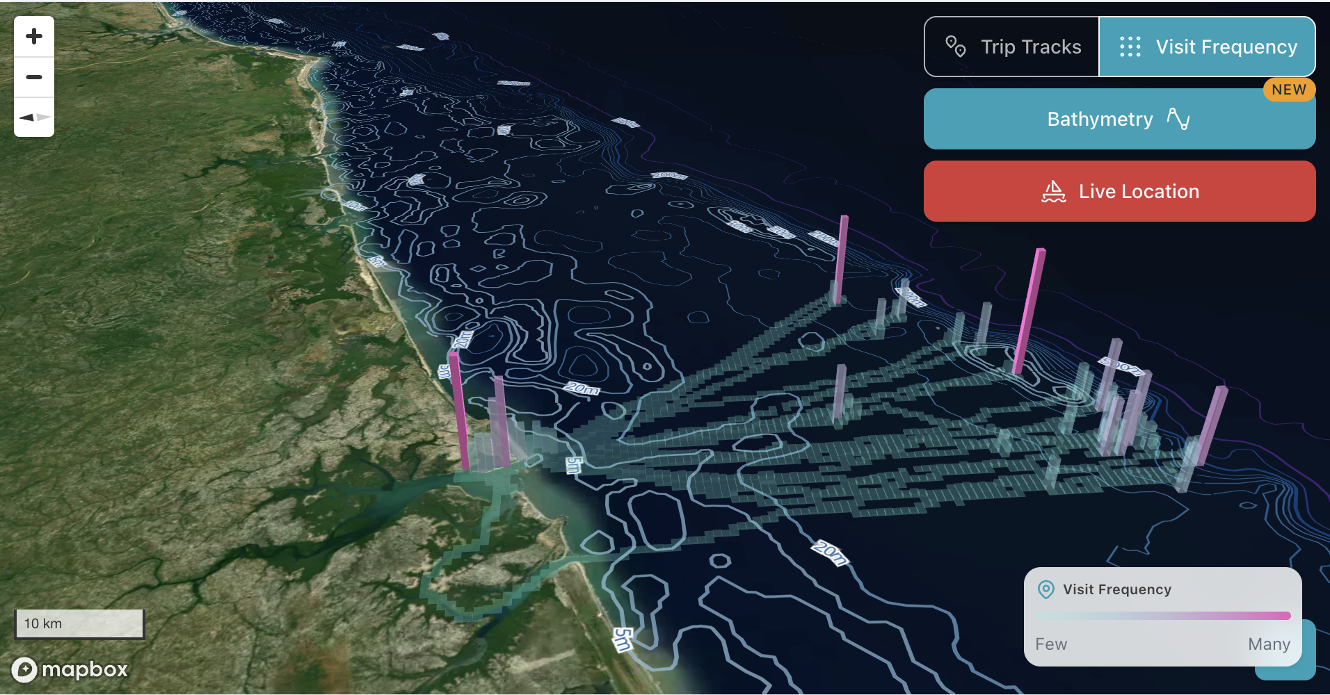
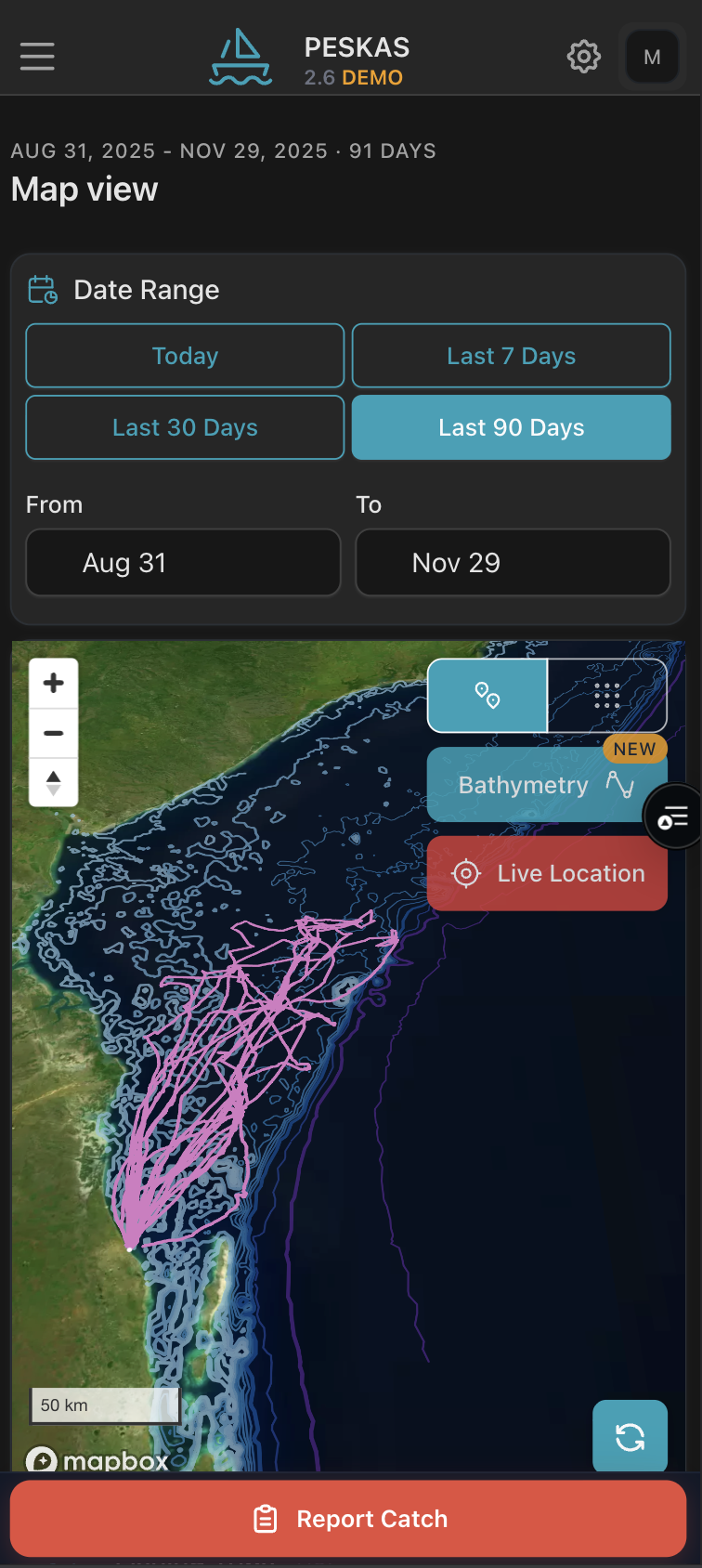
The app is accessible via both mobile and web browsers, Tracks allows fishers and managers to view:
- Current position
- Trip routes
- Distance travelled
- Speed of travel
- Time spent at sea
Trips and movements can be visualized individually or grouped into heatmaps over different time frames—daily, weekly, or monthly, with vessel movements summarized with simple statistics such as:
- average number and length of trips
- average speed
- distance covered.
Fishers can also report their own catch directly in the app, and associate this data with a specific trip, enabling a more accurate and complete picture of fishing activity. The interface is currently available in English, Portuguese and Swahili. Trip and catch data are password protected so can only be viewed and accessed by the registered fisher.
When connected to the internet, the app can display and send the live vessel location but also works offline to record positions and catches as necessary.
Future updates aim to expand functionality for safety-at-sea in low-connectivity environments as Tracks continues to evolve with user feedback.
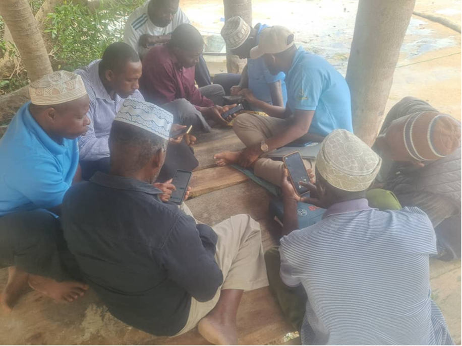
Piloting Across Kenya and Tanzania
The app has so far been piloted with more than 100 fishers from 20 landing sites across Kenya’s five coastal counties—Kwale, Mombasa, Kilifi, Tana River, and Lamu—and among a smaller group of fishers in Tanzania.
These fishers are associated with boats already equipped with satellite-based trackers as part of AABS activities. Fishers have responded positively, noting how Tracks helps them to plan routes and manage fuel use.
Training sessions and direct technical support from WorldFish staff on the ground have helped fishers and managers learn how to interpret trip data and use the system to plan more efficient, transparent, and sustainable fishing operations. There are also plans to add a learning portal, where fishers can access eLearning modules relevant to their businesses and marine resources.
Case Story: When Data Helps Bring Fishers Home Safely
In September 2025, when one of his vessels failed to return on time, a Kenyan boat owner feared the worst. Unable to reach the crew by phone, he contacted the WorldFish team. Using the Tracks system, the team quickly located the vessel and confirmed that it had experienced engine trouble but was safe.
That reassurance—and the ability to see the vessel’s location—transformed the owner’s confidence in the technology. 'Before Tracks, we could only guess where our boats were,' he said. 'Now we can see them, plan better, and fish smarter.'
Empowering Fishers, Strengthening Management
Stories like this show how Tracks goes beyond safety to support smarter, more sustainable fisheries. Tracks is helping fishers understand which grounds are most productive, track their performance, and plan future trips more efficiently. Accurate records of effort and catch supplied to the market also serve as solid evidence of their livelihoods to demonstrate to new buyers and secure access to government schemes or financial services such as credit and insurance.
For managers, the benefits are equally clear. Real-time submissions and vessel-level data provide a high-resolution picture of fishing effort that can inform stock assessments, identify overfished areas, and guide adaptive co-management plans between Beach Management Units (BMUs).
Looking Ahead
By early 2026, Tracks will be available to all small-scale fishers in Kenya, Tanzania and Mozambique, including those without installed vessel trackers. Its design will continue to evolve through co-creation with fishers, government agencies, and community organizations to ensure it remains responsive and relevant.
The long-term vision is for Tracks to become part of an integrated regional monitoring system, helping countries share insights, strengthen ocean governance, and promote inclusive digital transformation across the Western Indian Ocean. Tracks isn’t just a tool - it’s part of a movement toward data-driven ocean governance across East Africa
Learn More
See Tracks in action — explore the demo of real fishing tracks and trip visualizations at tracks.peskas.org.
Tracks is developed by WorldFish under the Digital Coasts work package of the Asia–Africa BlueTech Superhighway project, funded by the UK’s Foreign, Commonwealth and Development Office (FCDO) and implemented in partnership with national fisheries agencies and community organizations in East Africa.